Haku
Viitteet 1-10 / 52

Carte de la partie meridionale du royaume de Suede avec une table des provinces et villes principales
([Amsterdam]: [F. l'Honore & Chatelain], 1718, 1718)

A new map of the Northern States containing the Kingdoms of Sweden, Denmark, and Norway; with the western parts of Russia, Livonia, Courland & ca.
(London: printed for Robert Sayer, 1790, 1790)

A new map of the Baltick & c.: shewing all the dominions about it with ye great or post roads and principal cross-roads
([London]: [Herman Moll], ca. 1720, 1720)

Tabula Geographica Regnorum Sveciae Daniae et Norwegiae : ad emendatiora Exempla adhuc edita jussu Acad. Reg. scient. et litter. eleg. Boruss. descripta
([Berolini]: [Ex officina Michaelis], 1753, 1753)
Danmark Norge og Sverriges Riger med angrændsende Russiske Provincer forfærdiget udi Kiöbenhavn 1778
([Köbenhavn]: [kustantaja tuntematon], 1778, 1778)

Suite du Golphe de Bothnie tiré des cartes Suédoises
([Paris], 1764)

Carte du Golphe de Bothnie
([Paris], 1764)
Il regno di Svezia diviso nelle sue Privincie e delineato sulle ultime oservazioni
(Roma: Presso la Calcografia Cam[era]le, 1796, 1796)
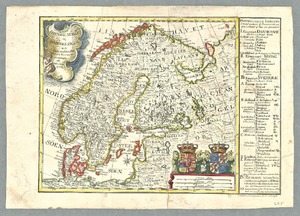
Des Königreichs Schweden nördliche Provinzen. Nro. 70
([Vienna]: [F. J. J. von Reilly], [1791], 1791)

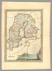
Des Königreichs Schweden mittlere Provinzen. Nro. 69
([Vienna]: [F. J. J. von Reilly], [1791], 1791)